

A Hundred and Seventy Years of the Same Problem
Staunton's Wharf District has been rebuilding on the same flood-prone ground since the railroad arrived in 1854.

Just before nine o’clock on the night of August 8, 2020, the sky over downtown Staunton opened up and refused to let go. Rain fell at close to four inches an hour, and within forty minutes the city had a flash flood warning covering Staunton, Fishersville, Verona, Swoope, and Mint Spring. Central Avenue turned into a river. Employees at Chicano Boy Taco climbed onto the roof and into nearby trees to escape rising water in the Wharf District, where the worst damage concentrated along Byers Street and the Wharf parking lot. The city’s own after-action report counted 166 reports of property damage and $3.1 million in losses by the time the water receded.
For anyone who lived through it, that night needs no introduction. What might surprise you is how familiar the scene would have looked to someone standing in roughly the same spot in 1896, or 1911, or 1940. The Wharf District has been doing this since the day it was built. The flooding is not a modern inconvenience visited upon an old neighborhood. It is close to the oldest fact about the place.
A Meadow Becomes a Shipping Point
Before the 1850s, the land that became the Wharf District was just that: a meadow. Locals once called it A.H.H. Stuart’s Meadow, with a creek running quietly through open ground south of downtown. Everything changed in 1854, when the Virginia Central Railroad reached Staunton. The arrival of the line, according to the Virginia Department of Historic Resources, turned the city from a quiet Shenandoah Valley town into an active regional shipping point almost overnight.
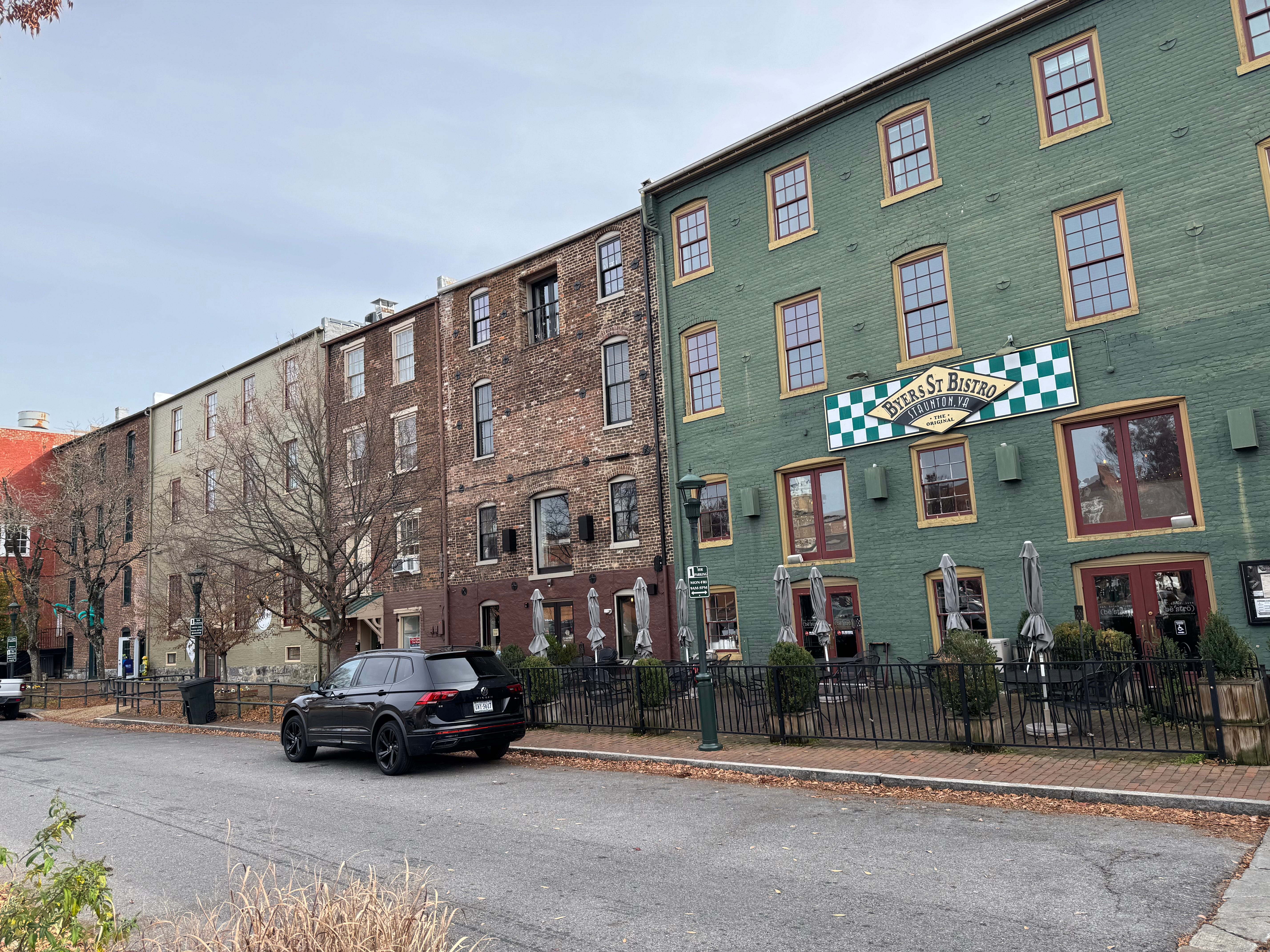
Warehouses sprang up across from the depot, mostly built between 1870 and 1910 to handle the flow of farm goods, dry goods, and wholesale merchandise moving in and out by rail. Workers carried produce and supplies between train cars and storage buildings along wooden gangplanks, a detail that has become the popular explanation for the district’s name. The state’s own historic register tells a plainer story: there was never a body of water here at all. The Wharf got its name because the area functioned like a harbor for goods, a landlocked shipping point dressed in the language of one.
By the turn of the century the district was a working neighborhood in the full sense. Commission merchants, wholesale grocers, saloon keepers, distilleries, and liveries operated alongside the warehouses, and the Greek Revival American Hotel, built in the mid-1850s, hosted travelers passing through on the rail line, including President Ulysses S. Grant during an overnight stay in 1869. Streetcars pulled by mustang mules carried passengers through the district at its commercial peak, weaving between brick warehouses ornamented with elaborate window hoods and bracketed cornices, many of them designed by the prolific local architectural firm T.J. Collins and Son.
None of it sat on solid, dry footing. Underneath the meadow, and later underneath the warehouses, Lewis Creek had always run its course toward the South River. The builders of the 1870s and 1880s were not ignoring a hazard so much as failing to recognize one. The creek would make its presence known soon enough.
The Flood That Set the Standard
On September 30, 1896, rain that had been falling steadily through the day picked up through the evening and turned, by nightfall, into one of the worst storms the Shenandoah Valley had seen. The system is believed to have been the remnant of a tropical storm, and it hit Staunton harder than any other community in the region. Lewis Creek and its tributaries overflowed their banks, tearing through downtown Staunton with enough force that observers compared the aftermath to earthquake damage rather than flood damage. Houses, sheds, and stables were swept away. A railroad bridge washed out along with one in Waynesboro.
The storm became known as the Flood of 1896, and for the City of Staunton it set a benchmark that stood for more than a century: the flood of record, the one against which every later flood would be measured.
It would not be the last disaster the district absorbed. According to the Historic Staunton Foundation’s own walking tour materials, the Wharf’s warehouses were damaged by the 1896 flood and then destroyed by fire, not once but twice, first in 1911 and again in 1940. The bungalow-style train depot that still stands on Middlebrook Avenue today is, in fact, the third station built on that site. The first burned during the Civil War. The second met its end in 1890, demolished by a runaway train.
Fire, flood, and war: the district’s own historic marker leans into the pattern rather than away from it, describing a neighborhood whose surviving architecture is notable precisely because so much of it managed to survive.
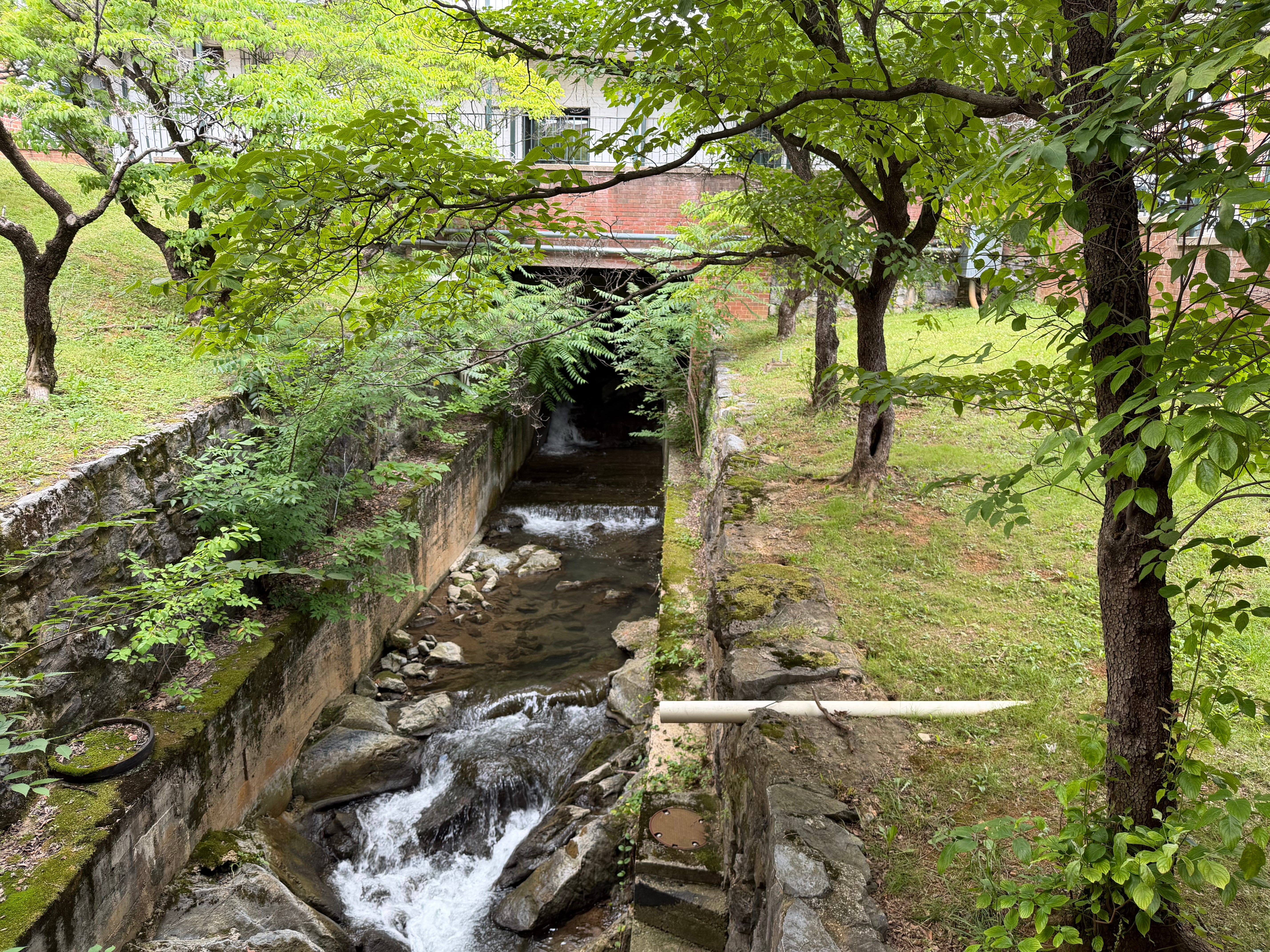
What’s Actually Underneath
The reason none of this is ancient history is that the creek never left. Lewis Creek still flows beneath the Wharf District today, and so does Peyton Creek, both routed through a tunnel system that carries them under modern Staunton rather than around it. Where the two creeks meet beneath the Wharf parking lot, the city has identified what engineers call a chokepoint, a narrowing in the underground channel that backs up water during heavy storms and contributes directly to surface flooding above it.
After the August 2020 flood, the city commissioned Wiley|Wilson to conduct a hydraulic and hydrologic study of the downtown drainage system, modeling roughly 3,500 linear feet of Lewis Creek from Pump Street to Greenville Avenue and a six-hundred-foot-wide inundation zone running through the Wharf itself. The findings were not encouraging. Staunton’s floodplain administrator, John Glover, told WHSV two years after the flood that the city had essentially concluded there was no reasonable combination of pipes or dams that could eliminate flooding of that magnitude. What the city can do, and has been doing, is reduce the damage at the margins.
That work has included a 2003 FEMA hazard mitigation grant that funded flood shields and other floodproofing measures for businesses along Central and Lewis streets and in the Wharf area, installed because so many of the district’s historic buildings sit below modern street grade. More recently, the city partnered with a Virginia nonprofit and the U.S. Department of Homeland Security to install flood sensors that give property owners earlier warning when water starts to rise, with ownership of the sensor network transferring to the city after the project’s completion. None of it promises to stop the next flood. All of it is built around the assumption that there will be one.
A Neighborhood That Keeps Choosing to Come Back
What makes the Wharf District’s history worth telling isn’t that it floods. Plenty of places near creeks flood. What stands out is how consistently the district has been rebuilt on the same ground, by people who knew exactly what that ground was capable of doing to them.
After 1896, the warehouses went back up. After the 1911 fire, they went back up again. After 1940, again. After a 1987 fire in the freight house nearly led to the demolition of the entire rail complex, an Atlanta couple, Vic and Linda Meinert, bought the property and rehabilitated it instead, work supported by federal historic preservation tax credits and city infrastructure investment in new sewer lines and rebuilt sidewalks. After August 2020, the businesses along Byers Street that could reopen, did. Some did not survive the loss, but the district as a whole did what it has always done, which is absorb the damage and keep operating.
The next time water rises in the Wharf parking lot, and given the district’s history, there will be a next time, it will be doing what it has done since long before anyone built a warehouse on top of it. The creek was always there first.
Local history is a new section of The Stauntonian. If there is a story, a building, a person, or an era you want us to look into, write to Brad at brad@stauntonian.com.